Planning
Donabate Portrane Community Council has launched a dedicated planning page on its website to keep the local community informed about significant new planning applications in the area. This resource will provide timely updates on large-scale developments, enabling residents to stay aware of proposals that could impact the community. Additionally, the page will outline the Community Council’s responses to these applications, ensuring transparency and fostering community engagement. By offering insights into the planning process and advocating for the area’s best interests, this initiative aims to empower residents and strengthen the collective voice in shaping Donabate and Portrane’s future development.
2025
Cairn Homes Properties Ltd. Lands south of Main Street (Incl Smyth’s Bridge House), Corballis East, Donabate.
Location: Lands south of Main Street (Incl Smyth’s Bridge House), Corballis East, Donabate.
Applicant: Cairn Homes Properties Ltd.
Planning reference no. LRD0070/S3E
Lodgement date: 11 Nov 2025
Final date for third-party observations/submissions: 16 Dec 2025
Decision date: N/A
Decision: N/A
Cairn Homes Properties Limited intends to apply for permission for a Large Scale Residential Development (LRD), consisting of amendments the permitted Phase 1 Development (FCC Reg. Ref. F20A/0204 (ABP-308446-20) as amended by FCC Reg. Ref. LRD0017/S3 (subject to a concurrent amendment application under LRD0064/S3E)), at this site comprising lands south of Main Steet and including Smyth’s Bridge House (a Protected Structure), Corballis East, Donabate, County Dublin.
The proposed development seeks to amend permitted Phase 1 Development (FCC Reg. Ref. F20A/0204 (ABP-308446-20) as amended by FCC Reg. Ref. LRD0017/S3), on a site of 0.708 ha. The development will consist of:
1. Modifications to the northern portion of the permitted Phase 1 Development to:
• Omit previously permitted commercial car parking (44 no. spaces in total);
• Omit permitted Block 1 (comprising 2 no. commercial units (216 sqm) and 4 no. 2-bed duplex units) and associated car parking, and replace with a new part single, part two storey commercial building comprising 4 no. retail units at ground floor (approx. 329 sqm) and 1 no. community use space at first floor level (approx. 158 sqm); and 2 no. 4-bed, three storey, under-parked Semi-Detached Houses (186.6 sqm GFA each) to the south of the commercial building;
• Provide a new village garden and reconfigured civic space incorporating a new playground, a natural play area, bicycle parking, bin storage, and all associated landscaping works;
• Incorporate a new loading bay and pedestrian footpath at Main Street, adjacent to Smyth’s Bridge House (a Protected Structure), and associated reconfiguration of the public road to include a new raised table toucan crossing; and
• Amend the surface treatment on Main Street carriageway to provide high quality natural stone paving at the raised table.
The proposed amendments result in an overall decrease in residential units in the permitted Phase 1 Development from 54 no. as permitted to 52 no. proposed, and an increase in total new commercial floor area from 216 sqm to 329 sqm GFA (excluding additional commercial floor area associated with Smyth’s Bridge House and the former Coach House & Barn as detailed below) and a new community space of 158 sqm GFA.
2. Incorporation of Smyth’s Bridge House (a Protected Structure), its associated outbuildings and the former Coach House and Barn into the Phase 1 public realm and the associated conservation and refurbishment of the existing buildings including the following works:
• Conservation works at Smyth’s Bridge House (a Protected Structure) for continued public house and restaurant use (411 sqm GFA) including removal of the existing render and replacement with lime render to the North, East, and West facades; replacing an existing door with a window to the North elevation, localised repairs to roof; removal of security railings to openings; provision of cast iron rainwater pipes; upgrading of mechanical and electrical services; and associated external and internal works including removal of non-original bandstand to rear;
• The conservation and adaptation of 2 no. outbuildings to Smyth’s Bridge House, for use ancillary to public house use, and commercial use (42 sqm and 66 sqm GFA, respectively), including repair to roof timbers, salvage and reuse of existing natural slates; repair and repointing of external stone walls; fitting of replacement sash windows and timber doors; insulating internal walls and floor; forming new openings x 2 and modifying an existing opening addressing public realm to east; removal of non-original walls and erection of new walls and all associated external and internal works;
• The conservation and adaptation of the Coach House & Barn, for restaurant/café use (217 sqm GFA), including removal and reuse of existing slates; construction of new timber roof structure; repair and repointing of external stone walls; provision of cast iron rainwater pipes; insulating internal walls and floor; reinstatement of the mezzanine level, installation of new sash windows and doors; forming new openings in north, east and west elevation; provision of cast iron rainwater pipes; creation of outdoor seating area to west of building; and all associated external and internal works;
3. Modifications to access to the permitted Phase 1 to facilitate vehicular access to residential car parking associated with the 14 no. permitted houses and 2 no. proposed houses, via the permitted Large Scale Residential Development (LRD) Scheme (LRD0017/S3) together with all associated amendments necessary to tie-into the LRD street network. Vehicle access to Phase 1 residential car parking will not be possible via Main Street. Pedestrian and cycle connectivity will be maintained through Phase 1 from Main Street to the LRD Scheme (LRD0017/S3) via the permitted shared cycle street. It is noted that LRD0017/S3 is subject to a separate, concurrent, amendment application under LRD0064/S3E which does not impact on the proposed development.
4. Modifications to the permitted street layout to incorporate a two-way shared active travel route from Main Street through the civic space and village garden leading to the permitted cycle street. The modifications also include provision of a new fully segregated two-way cycle track and footpath to the south, providing connectivity to the permitted two-way cycle tracks and footpaths within the permitted LRD development which form a direct link with the pedestrian and cycle facilities at the Donabate Distributor Road.
5. All associated site and development works necessary to implement the proposed amendments and proposed conservation and restoration of the existing buildings.
For more information, click here
DPCC response here
Glenveagh Living Limited, development on lands at Ballymastone, Donabate, Co. Dublin.
Location: Ballymastone, Donabate, Co Dublin
Applicant: Glenveagh Living Limited
Planning reference no. LRD0053/S3
Lodgement date: 23 Oct 2025
Final date for third-party observations/submissions: 26 Nov 2025
Decision date: N/A
Decision: N/A
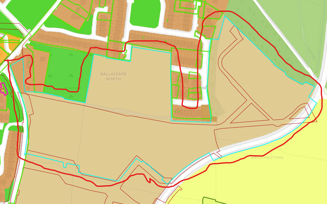
We, Glenveagh Living Limited, intend to apply for permission for a Large-Scale Residential Development (LRD) at this site at Ballymastone, Donabate, County Dublin.
The application site, of c. 11.28ha, is bounded by existing residential developments of Willowbrook, The Priory and Priory Wood, and Donabate Burial Ground to the
north/northwest, the Donabate Distributor Road (DDR) to the east, permitted Ballymastone Phase 2 (FCC. Ref. LRD0039/S3 & ABP Ref. 320885) to the south, and
the Links Road to the west. A portion of the subject site is within the St. Ita’s Hospital Complex Architectural Conservation Area (ACA).
The proposed development will consist of the construction of a residential development, which is a continuation of permitted Ballymastone Phase 1 lands (FCC Ref.
LRD0008/S3 & ABP Ref. 315288) and Phase 2 lands (FCC. Ref. LRD0039/S3 & ABP Ref. 320885) and represents Phase 3 of the wider development of the Ballymastone
Lands (as identified in the Donabate Local Area Plan 2016 (as extended)), ranging in height from 2- to 6-storeys to accommodate 398 no. residential dwellings (227
no. houses, 47 no. duplex units and 124 no. apartments) and public open space. The site will accommodate 316 total no. car parking spaces, 1,619 total no. cycle
parking spaces, pedestrian / cycle links, road connectivity enhancements, storage, services and plant areas. Landscaping will include significant public open space
provision and communal amenity areas. The proposed development consists of:
1. The construction of 398 no. new residential dwellings consisting of 227 no. houses, 47 no. duplex units and 124 no. apartment units set out follows:
• Construction of 227 no. 2-storey houses (81 no. 2-beds, 134 no. 3-beds, 12 no. 4-beds).
• Construction of 47 no. 2- to 3-storey duplex units (2 no. 1-beds, 24 no. 2-beds, 21 no. 3-beds), with balconies on rear elevations.
• Construction of 3 no. apartment blocks, ranging from 3- to 6-storeys in height, with balconies on all elevations, green roofs, and external communal
amenity spaces, providing a total of 124 no. apartment units (47 no. 1-beds, 68 no. 2-beds, 9 no. 3-beds);
2. Provision of a crèche (c. 646 sq.m) and a community space (c. 100 sq.m) located within the footprint of proposed apartment block to the west of the site;
3. Provision of c. 15.3% public open space of the net site area, comprising 3 no. small parks and 4 no. pocket parks which total c. 17,287 sq.m. These parks are
generally located centrally within the site providing a series of north-south linear spaces linking to the permitted Ballymastone Phase 2 (FCC Reg. Ref. LRD0039/S3
& ABP Reg. Ref. 320885) with onward connection to the permitted Ballymastone Phase 1 (FCC Reg. Ref. LRD0008/S3 and ABP Reg. Ref. 315288) to the south;
4. Provision of a total of 316 no. car parking spaces are provided (combination of in-curtilage and on-street and communal car parking areas);
5. Delivery of a total of 1,619 no. cycle spaces (comprising 1,513 no. long-stay/resident spaces and 106 no. short-stay/visitor spaces);
6. Provision of vehicular access from The Links road to the west of the site and the Donabate Distributor Road (DDR) to the east of the site;
7. Provision of an east-west pedestrian/cycle route is proposed within the site connecting the existing Links Road to the west and DDR to the east, in addition to a
connection to the permitted east/west pedestrian/cycle route which forms part of the permitted Ballymastone Phase 2 (FCC. Ref. LRD0039/S3 & ABP Ref. 320885);
8. The proposed application includes all site enabling and site development works, infrastructure and utilities, landscaping works and boundary treatments
(including at the permitted foul pump station as per FCC Reg. Ref. LRD0039/S3 & ABP Reg. Ref. 320885), solar PV panels, bin and bicycle stores, plant, ESB unit
substations, lighting, servicing, signage, surface water attenuation features and all site development works above and below ground.
An Environmental Impact Assessment Report and a Natura Impact Statement have been prepared in respect of the proposed development.
The application may also be inspected online at the following website set up by the applicant: www.ballymastone3lrd.ie
For more information click here
DPCC response here
Keelco Limited, development on lands at St. Mary’s, Main Street, Ballalease West, Donabate,
Location: On Lands at St. Mary’s Main Street, Ballalease West, Donabate, Co. Dublin
Applicant: Keelco Limited
Planning reference no. F25A/0950E
Lodgement date: 15 Oct 2025
Final date for third-party observations/submissions: 18 Nov 2025
Decision date: N/A
Decision: N/A
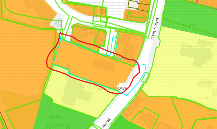
We, Keelco Limited, intend to apply for permission for development on lands at St. Mary’s, Main Street, Ballalease West, Donabate, Co. Dublin and including the existing car park at Ballisk Court, Ballalease West, Donabate, Co. Dublin.
The proposed development consists of demolition of the existing detached single-storey St. Mary’s building and the construction of a mixed-use development, in 2 no. blocks, comprising residential, retail, office, and community use. The development will provide for:
Block A will be a 3-storey (1-storey rising to 3-storeys) commercial block comprising of:
– 1 no. retail unit and 1 no. retail/office unit at ground floor level; 2 no. Offices and associated bathroom, kitchen, and staff areas at 1st floor level; and 1 no. Office and associated bathroom, kitchen, and staff areas at 2nd floor level; with a roof terrace also located at 1st floor level.
Block B will be a 3-storey (1-storey rising to 3-storeys) mixed-use block comprising of:
– 1 no. café & coffee shop, 2 no. retail units, and 1 no. community centre unit, along with bin store, and bike store at ground floor level;
– 1 no. 2-bed/3-person apartment unit and associated balcony; 2 no. office units with associated private outdoor area; and 1 no. enterprise centre on the 1st floor and 2nd floor levels with a roof terrace at 1st floor level; and
– 1 no. 1-bed apartment, 1 no. 2-bed/3-person apartment, and 1 no. 2-bed/4-person apartment all with balconies at 2nd floor level.
The proposal includes the use of 6 existing designated parking spaces within the existing Ballisk Court car park; the provision of 47 cycle parking spaces; landscaping; boundary treatment and all associated site and infrastructural works necessary to facilitate the proposed development. Pedestrian and vehicle access to the development will be via Main Street and via a new step and ramp access to Ballisk Court. Emergency vehicular access will be via Main Street.
For more information, click here
DPCC response here
Corballis East, Donabate, County Dublin. LRD Amendents 2025
Location: Corballis East, Donabate, County Dublin
Applicant: Cairn Homes Properties Ltd.
Planning reference no. LRD0064/S3E
Lodgement date: 26 Aug 2025
Final date for third-party observations/submissions: 30 Sep 2025
Decision date: N/A
Decision: N/A
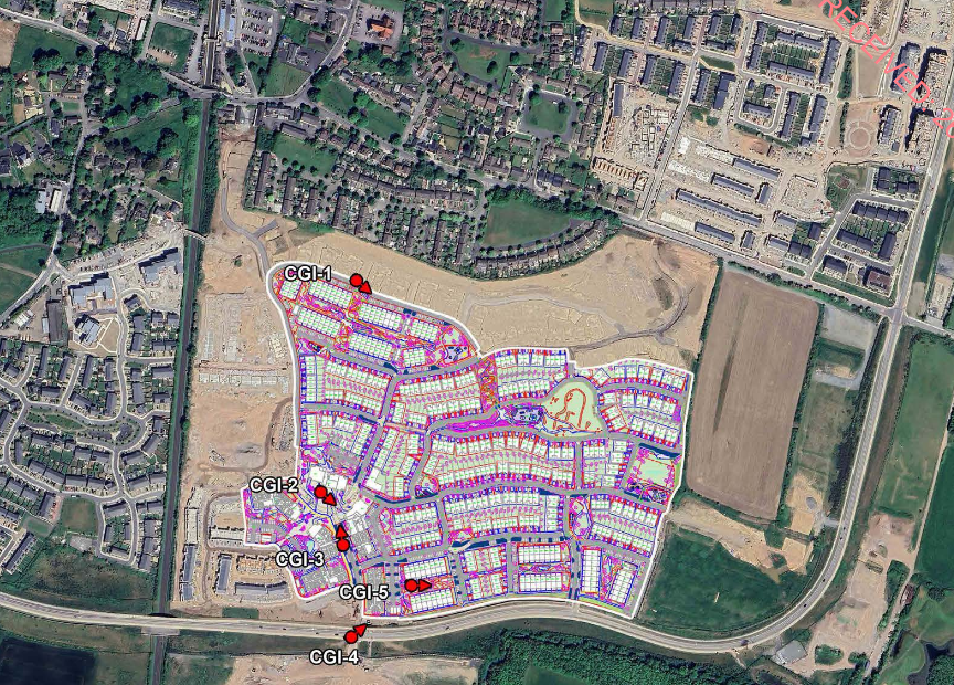
Cairn Homes Properties Limited intends to apply for permission for a Large Scale Residential Development (LRD), consisting of amendments to a LRD permitted under FCC Reg. Ref. LRD0017/S3, at this site at Corballis East, Donabate, County Dublin
The proposed amendments relate to part of the Main Residential Development Site, as permitted under LRD0017/S3, to the north of the Donabate Distributor Road (DDR) only. The application site is generally bound by part of the Main Residential Development Site (as permitted under LRD0017/S3) to the west and north, by agricultural lands to the east and the Donabate Distributor Road (DDR) to the south. No changes are proposed to the permitted Nature Park to the south of the DDR.
The proposed development will consist of the following amendments to LRD0017/S3 (a 10-year permission):
• Omission of previously permitted triplex units; reduction in the number of duplex units; introduction of back-to-back townhouse house type; and rationalisation of the total number of house types, including replacement with updated house types.
• Replacement of previously permitted Apartment Blocks with revised Apartment Blocks generally in the same position. Apartment Block 2 is six storeys in height; Apartment Blocks 3, 4 & 5 are five storeys in height; and Apartment Blocks 6 & 7 are four storeys in height. All Apartment Blocks will have balconies/terraces on all elevations. Block 4 provides 65 no. apartments for Independent Living for ‘Older Persons’.
• Proposed amendments to the Local Centre retain the same number and range of uses to provide 3 no. retail units, 2 no. café units and a medical centre with a combined total gross floor area of 1,290 sqm gross floor area (GFA) increased from 730 sqm previously permitted; together with a multi-purpose community use unit of 140 sqm GFA (91 sqm previously permitted).
• Minor modifications to permitted public open space network at discrete locations, including the creation of new spaces, within the Main Residential Development Site resulting in an increase in total public open space from approximately 3.6ha previously permitted to 4.6ha proposed.
• Minor repositioning of permitted Creche A eastwards to facilitate improved access.
• All associated and ancillary infrastructure, landscaping, boundary treatments and development works associated with the proposed amendments within an area of approximately 17.52 hectares
The proposed amendments result in an overall decrease of 21 no. units, from 1,020 no. units previously permitted to 999 no. now proposed. The proposed amendments will result in an overall increase in the total number of apartments from 174 no. previously permitted to 278 no. proposed; a reduction in the total number of duplex/triplex units from 356 no. previously permitted to 45 no. proposed (duplex units only); and, an increase in the total number of houses from 490 no. previously permitted, to 676 no. now proposed (including 182 no. back-to-back townhouses).
The proposed amendments result in an overall development, that includes the permitted units that are not included within this application, of 999 no. dwellings comprising 130 no. one-bed apartments; 138 no. two-bed apartments and 10 no. three-bed apartments arranged in 6 no. blocks (including 65 no. Independent Living units comprising 53 no. one-bed and 12 no. two-bed apartments); 21 no. one-bed, 2 no. two bed and 22 no. three bed duplex units; and 29 no. two-bed houses; 530 no. three-bed houses; 109 no. four-bed houses and 8 no. five-bed houses on an overall net site area of 25.42 hectares.
The proposed amendments result in an increase in car parking from 902 no. car parking spaces permitted to 922 no. car parking spaces (comprising 844 no. residential spaces; 11 no. childcare facility drop off spaces, 67 no. on-street visitor parking). Bicycle parking spaces will increase from 3,013 no. spaces permitted to 3,291 no. spaces (comprising 3,086 no. long stay spaces and 205 no. short stay spaces). No changes are proposed to vehicular access; pedestrian or cycle access or connections; and the main internal street network or street levels except for some minor modifications to shorter cul-de-sac streets.
An Environmental Impact Assessment Report (EIAR) and a Natura Impact Statement (NIS) have been prepared in respect of the proposed amendments. The application, including EIAR and NIS, may also be inspected online at the following website set up by the applicant: www.corballisamendmentlrd.com
For more information click here
Planning permission for development at a 0.578 Hectare Site Located To The West Of ‘The Paddocks’
Residential Development And To The East Of The Donabate Portrane Educate Together National
School, Ballisk Common, Donabate, Co. Dublin. 2025
Location: A 0.578 Hectare site located to the West of ‘The Paddocks’ Residential Development and to the East of the Donabate Portrane Educate Together National School, Ballisk Common, Donabate, Co. Dublin.
Applicant: Grelis Limited
Planning reference no. F25A/0730E
Lodgement date: 12 Aug 2025
Final date for third-party observations/submissions: 15 Sep 2025
Decision date: 6 Oct. 2025
Decision: REFUSE PERMISSION
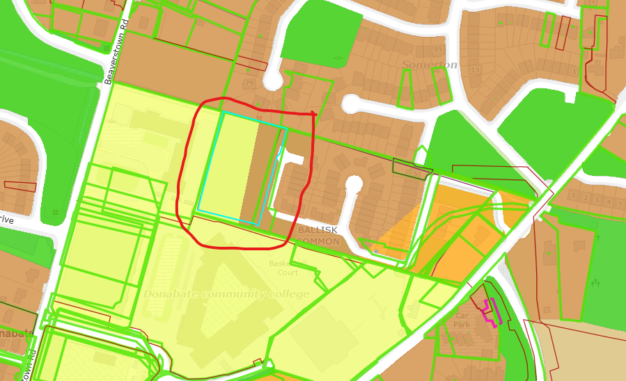
The development will consist of a residential scheme providing 28 no. units in total. The scheme comprises: (i) the construction of 9 no. two-storey buildings, consisting of 17 no. one-bedroom apartments and 1 no. ground floor level community facility in the form of a multi-purpose room with storage space. A communal garden is provided to the rear of the proposed communal facility. Each of the 17 no. apartments proposed is provided with private amenity space to the rear (west) and 1 no. car parking space provided to the front (east). These 17 no. one-bedroom apartments and the associated communal facility are provided on-site for visually impaired persons and will be provided in association with The National Association of Housing For The Visually Impaired (NAHVI), an Approved Housing Body (AHB). The proposed development also includes: (ii) the construction of 11 no. two-storey, three bedroom, terraced dwellings, each served with private amenity space to the rear and 1 no. on-curtilage car parking space; (iii) the provision of 1,018 sq.m of open space; (iv) the provision of new road surfaces and footpaths, with access to the development site provided from the existing road network in ‘The Paddocks’ Residential Development to the east; and (v) all associated works including landscaping, boundary treatments and drainage, necessary to facilitate the development.
For more information click here
DPCC response: Click here
3 CONDITIONS(S) AND REASON(S) FOR REFUSE PERMISSION
1: Based on the information submitted the proposed development provides a number of houses on lands zoned for Community Infrastructure where residential development is not permitted (and no information has been provided to demonstrate sheltered accommodation by a public operator as required in the Fingal County Council Development Plan 2023-2029). As such, it is considered of the proposed development contravenes the ‘CI’ land-use zoning objective detailed in the Fingal Development Plan 2023-2029 and would, therefore, be contrary to the proper planning and sustainable development of the area.
2: The proposed development fails to make efficient use of the existing access road running to the east of the site and fails to provide for adequate levels of passive surveillance or high-quality frontage on to existing and proposed roads and areas of proposed public open space. The proposed development does not appropriately integrate into the existing development in the vicinity and would not protect, improve or enhance residential amenity in the existing area and, therefore, by reason of the proposed design and layout is considered to contravene objectives SPQH01 and SPQH02 and SPQH034 and Objective DMS04 and the ‘RS’ land-use zoning objective and vision of the of Fingal Development Plan 2023-2029. The proposed development would, therefore, be contrary to the proper planning and sustainable development of the area.
3: The applicant has failed to submit a building lifecycle report for the proposed apartment development, as required under Section 6.2 of the ‘Planning Design Standards for Apartments Guidelines for Planning Authorities (2025)’. The proposed development therefore contravenes the requirements of Section 28 Ministerial Guidelines and would, therefore, be contrary to the proper planning and sustainable development of the area.
Marshall Yards Development, Corballis East 2025
Location: Corballis East, Donabate, Co Dublin
Applicant: Marshall Yards Development Company Limited
Planning reference no. F24A/1061E
Lodgement date: 27 Nov. 2024
Final date for third-party observations/submissions: 09 Jan 2025
Decision date: N/A
Decision: N/A
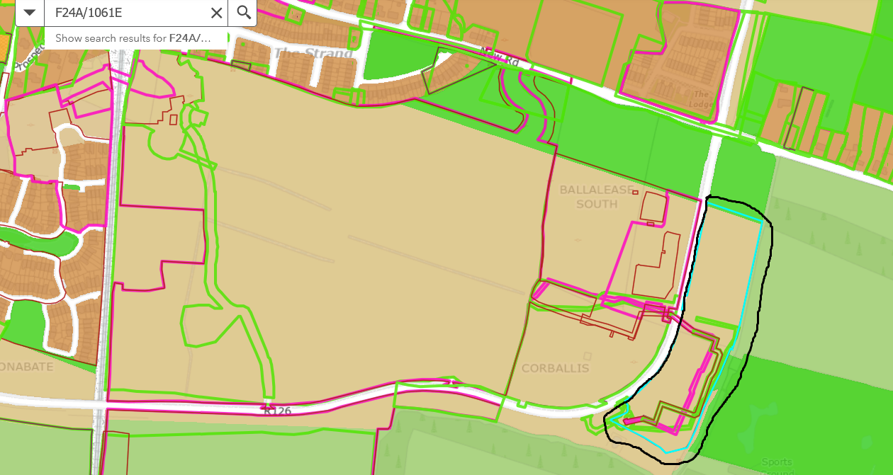
Planning permission is sought for a development which will have a Total Gross Floor Area of 7,982 sq m, will consist of: the construction of a Residential Development comprising 96 No. units including 80 No. two storey houses (51 No. 2 bed units and 29 No. 3 bed units), 4 No. three storey 4 bed houses and 3 No. two storey maisonette buildings comprising 12 No. 1 bed units.
The development will also include: vehicular and pedestrian connections to the Donabate Distributor Road; internal roads and footpaths; pedestrian connections to the adjoining sites to the north and east; 139 No. car parking spaces; bicycle and bin stores; hard and soft landscaping; balconies and terraces; boundary treatments; solar panels; 2 No. ESB substations; public lighting; and all other associated site and development works above and below ground. The site is generally bound to the north by greenfield lands, to the south by attenuation storage, to the east by greenfield lands and Balcarrick Golf Course, and to the west by Donabate Distributor Road.
For more information click here
DPCC response: Click here
2024
Marshall Yards Development, Corballis East 2024
Location: Corballis East, Donabate, Co Dublin
Applicant: Marshall Yards Development Company Limited
Planning reference no. F24A/0169
Lodgement date: 29 Feb 2024
Decision date: 16 Dec. 2024
Decision: GRANT PERMISSION

Marshal Yards Development company Limited intend to apply for a No. 7 year permission for development at this 3.84 Ha site in Corballis East, Donabate, Co. Dublin. The site is generally bound to the north by greenfield lands, to the south by lands with an extant permission for a Residential Development (Fingal County Council Reg. Ref. F22A/0527), to the east by the Donabate Distributor Road and to the west by lands subject to a Live Planning Application for a Large-Scale Residential Development (as per Fingal County Council Reg. Ref. LRD0017/S3). The proposed development partially amends the Residential Development permitted under Fingal County Council Reg. Ref.
F22A/0527. The development, which will have a total Gross Floor Area of 8,028 sq m, will consist of: the construction of a Residential Development comprising 98 No. units including 70 No. two storey houses (35 No. 2 bed units and 35 No. 3 bed units), 4 No. three storey 4 bed houses, and 6 No. two storey maisonette buildings comprising a total of 24 No. 1 bed units. The development will also comprise of: alterations to the access road associated with the Residential Development permitted under Fingal County Council Reg. Ref. F22A/0527; the provision of internal roads and footpaths; pedestrian connections to the Donabate Distributor Road; pedestrian and vehicular connections to the adjoining site to the west (subject to a Live Planning Application for a Large-Scale Residential Development as per Fingal County Council Reg. Ref. LRD0017/S3); 73 No. car parking spaces; 5 No. car club spaces; bicycle and bin stores; hard and soft landscaping; balconies and terraces; boundary treatments; solar panels; 2 No. ESB substations; public lighting; and all other associated site and development works above and below ground.
A Natura Impact Statement has been prepared in respect of the proposed development.
For more information click here
DPCC response: Click here
Balmaston Phase 2
Location: Lands at Ballymastone, Donabate, Co Dublin
Applicant: Glenveagh Living Limited
Planning reference no. LRD0039/S3
Lodgement date: 30 Apr 2024
Decision date: 28 Aug 2024
Decision: GRANT PERMISSION
Appeal lodged date: 23 Sept. 2024
Appeal decision date: 13 Jan. 2025
ABP reference no. ABP-320885-24
Appeal decision: Grant permission
Status Description: On 28 Aug 2024, a decision GRANT PERMISSION was made by Fingal County Council on this application. Subsequently, an appeal was lodged on 23 Sep 2024 and a decision to Grant Permission was made by An Bord Pleanala on 13 Jan 2025.
Phase 2
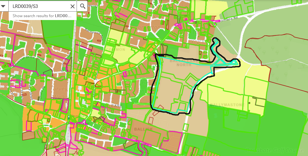
No1. The construction of 364 no. new residential dwellings consisting of 158 no. houses, 82 no. duplex units and 124 no. apartment units set out follows:
• Construction of 158 no. 2-storey houses (54 no. 2-beds, 99 no. 3-beds, 5 no. 4-beds).
• Construction of 82 no. 2 to 3 storey duplex units (8 no. 1-beds, 33 no. 2-beds, 41 no. 3- beds), with balconies on all elevations.
• Construction of 3 no. apartment blocks, ranging from 3 to 6 storeys in height, with balconies on all elevations, green roofs, and external amenity courtyards, providing a total of 124 no. apartment units (48 no. 1-beds, 66 no. 2-beds, 10 no. 3-beds).
2. The scheme provides c. 17% public open space of the net site area comprising 2 no. small parks and 1 no. pocket park which total c. 13,646 sq.m. These parks are located centrally within the site providing a series of north-south linear spaces linking to permitted Ballymastone Phase 1 (FCC Ref. LRD0008/S3 & ABP Ref. 315288) to the south.
3. A total of 278 no. car parking spaces are provided (in-curtilage for the houses and in a mix of both on-street and communal car parking areas for apartment and duplex units). A total of 1,457 no. cycle spaces are provided for residential units (comprising 1,353 long-stay/ resident spaces and 104 no. short-stay/ visitor spaces).
4. The development provides for vehicular access from The Links Road, Donabate Distributor Road (DDR) and permitted Ballymastone Phase 1 (FCC Ref. LRD0008/S3 & ABP Ref. 315288).
5. A north-south pedestrian/ cycle route is proposed within the site connecting permitted Ballymastone Phase 1 (FCC Ref. LRD0008/S3 & ABP Ref. 315288) and future development lands to the north. A series of east-west pedestrian/ cycle routes are proposed connecting the site to permitted Ballymastone Recreational Hub to the east (PARTXI/004/21).
6. Proposed new foul pump station located to the north-east of the site.
7. The proposed application includes all site enabling and site development works, landscaping works, PV panels, bin stores, plant, boundary treatments, ESB Substations, lighting, servicing, signage, surface water attenuation facilities and all site development works above and below ground.
An Environmental Impact Assessment Report and a Natura Impact Statement have been prepared in respect of the proposed development.
The application may also be inspected online at the following website set up by the applicant: www.ballymastonelrd2.ie
AI – received 8/7/24
For more information click here
DPCC response click here
DPCC appeal to ABP click here